The Canadian Rockies’ Best Backpacking Trips
The Canadian Rockies are just as wild and rugged as their American counterparts. Luckily, Parks Canada has made the best parts of it accessible to backpackers.
With its turquoise lakes, massive glaciers, towering peaks, and abundant wildlife, you can’t help but feel touched by the beauty of this place.
Here are my six favorite backpacking trips. They’re conveniently located near the towns of Banff and Jasper, the perfect basecamps for adventures.
When to go? The best time to go is from July to September. Every month has its pros and cons. You might encounter leftover snow in July. August is the most crowded, while September is when it starts getting chillier.
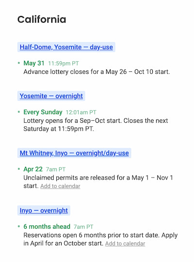
Permits. All these trips require wilderness permits. See below for current availabilities and permit requirements. Permits open up in January/February and run out quickly, but we can notify you when we find cancellations.

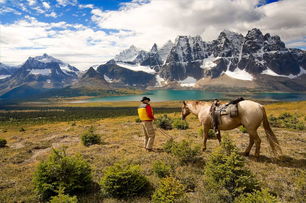
Mount Assiniboine
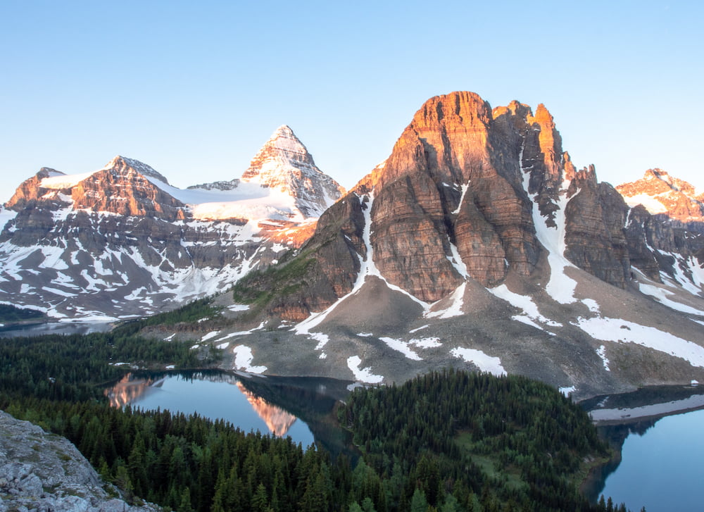
Mount Assiniboine, nicknamed the “Matterhorn of the Rockies”, is the classic backpacking trip near Banff. It’s also an extremely popular hike, so you’ll want to book your campsite at Lake Magog early.
For an easier start, the Sunshine Village Gondola can bring you up to the top of the resort and save 3 miles and 1,500 feet of elevation gain.
If you prefer loops, you can start from Bryant Creek Trailhead. It’s a little harder to plan since you must book campsites in both Mount Assiniboine Provincial Park and Banff National Park.
Permit availability
Updated every 10 min
Click for details
Click for details
Click for details
Click for details
Click for details
Click for details
Click for details
Click for details
Click for details
Click for details
Click for details
Click for details
Click for details
Click for details
Click for details
Click for details
Click for details
Click for details
Click for details
Click for details
Click for details
Click to get notified when we find any
Click to get notified when we find any
Click to get notified when we find any
Click to get notified when we find any
Click to get notified when we find any
Click to get notified when we find any
Click to get notified when we find any
Click to get notified when we find any
Click to get notified when we find any
Click to get notified when we find any
Click to get notified when we find any
Click to get notified when we find any
Click to get notified when we find any
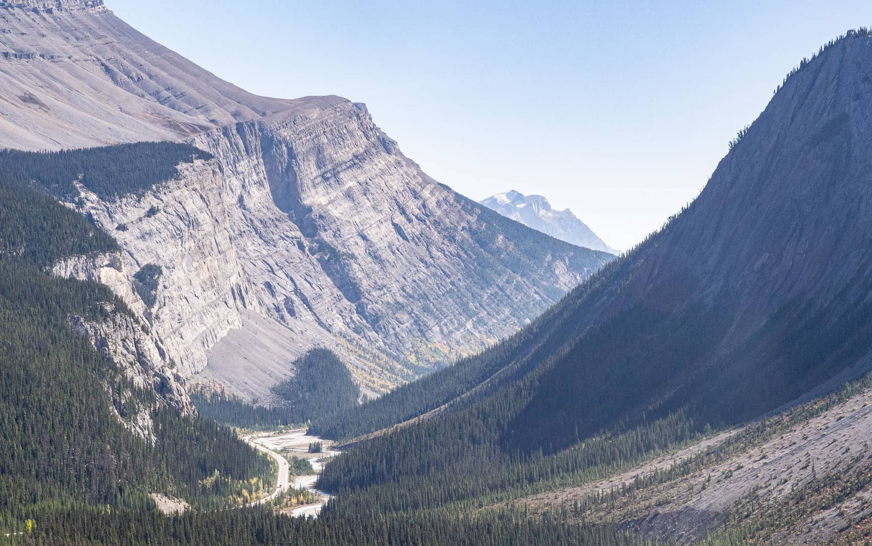
The Rockwall Trail
I wouldn’t be surprised if this trail inspired The Wall in Game of Thrones. For 20 miles, the Rockwall follows an impassable cliff from which hanging glaciers tumble down. A challenging, but rewarding hike.
It’s a point-to-point hike, so you’ll need to find a way to get back to your car. Hitch-hiking is a common option.
Permit availability
Updated every 10 min
Click for details
Click for details
Click for details
Click for details
Click for details
Click for details
Click for details
Click for details
Click for details
Click for details
Click for details
Click for details
Click for details
Click for details
Click for details
Click for details
Click for details
Click for details
Click for details
Click for details
Click for details
Click to get notified when we find any
Click to get notified when we find any
Click to get notified when we find any
Click to get notified when we find any
Click to get notified when we find any
Click to get notified when we find any
Click to get notified when we find any
Click to get notified when we find any
Click to get notified when we find any
Click to get notified when we find any
Click to get notified when we find any
Click to get notified when we find any
Click to get notified when we find any
Lake O’Hara
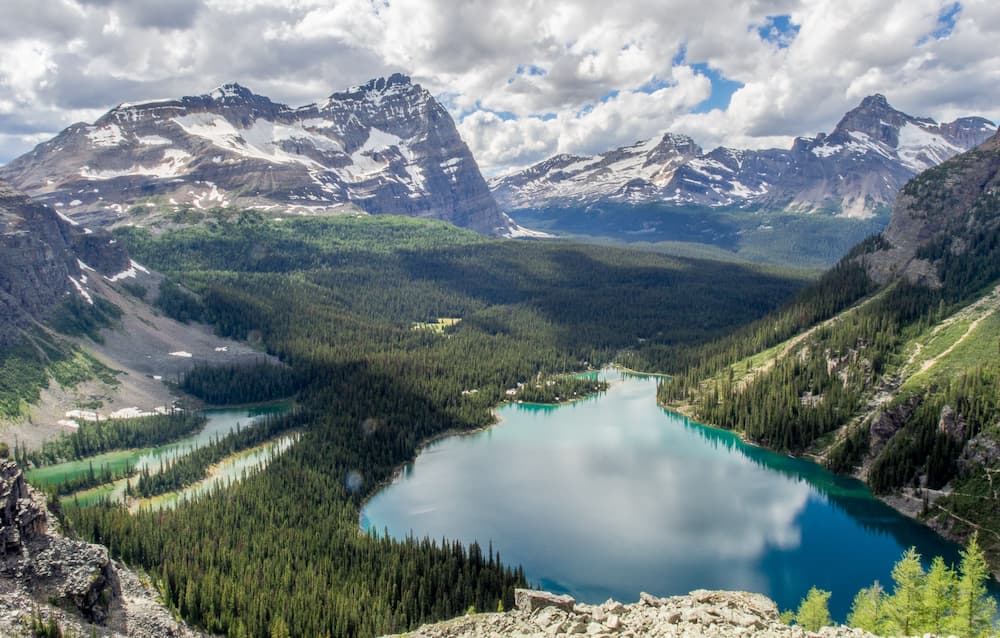
Lake O’Hara is most often done as a day-hike. A shuttle can drop you of at the lake to avoid the 7-mile approach. Getting a seat on the shuttle is competitive, but spots are reserved for those staying at the Lake O’Hara campground.
From the Lake O’Hara campground, the Yukness Ledges Alpine Route offers the best views of Lake O’Hara. It’s a short 7.5-mile loop with 2,500 feet of elevation gain.
Permit availability
Updated every 10 min
Click for details
Click for details
Click for details
Click for details
Click for details
Click for details
Click for details
Click for details
Click for details
Click for details
Click for details
Click for details
Click for details
Click for details
Click for details
Click for details
Click for details
Click for details
Click for details
Click for details
Click for details
Click to get notified when we find any
Click to get notified when we find any
Click to get notified when we find any
Click to get notified when we find any
Click to get notified when we find any
Click to get notified when we find any
Click to get notified when we find any
Click to get notified when we find any
Click to get notified when we find any
Click to get notified when we find any
Click to get notified when we find any
Click to get notified when we find any
Click to get notified when we find any
Tonquin Valley Trail
Tonquin Valley is one of the jewels of Jasper National Park. Camp at Amethyst Lakes to enjoy the reflection of The Ramparts at sunrise.
The trail starts and ends at different trailheads, so you’ll need to find a way to get back to your car after the hike (hitch-hike or bring two cars).
Permit availability
Updated every 10 min
Click for details
Click for details
Click for details
Click for details
Click for details
Click for details
Click for details
Click for details
Click for details
Click for details
Click for details
Click for details
Click for details
Click for details
Click for details
Click for details
Click for details
Click for details
Click for details
Click for details
Click for details
Click to get notified when we find any
Click to get notified when we find any
Click to get notified when we find any
Click to get notified when we find any
Click to get notified when we find any
Click to get notified when we find any
Click to get notified when we find any
Click to get notified when we find any
Click to get notified when we find any
Click to get notified when we find any
Click to get notified when we find any
Click to get notified when we find any
Click to get notified when we find any
The Skyline Trail
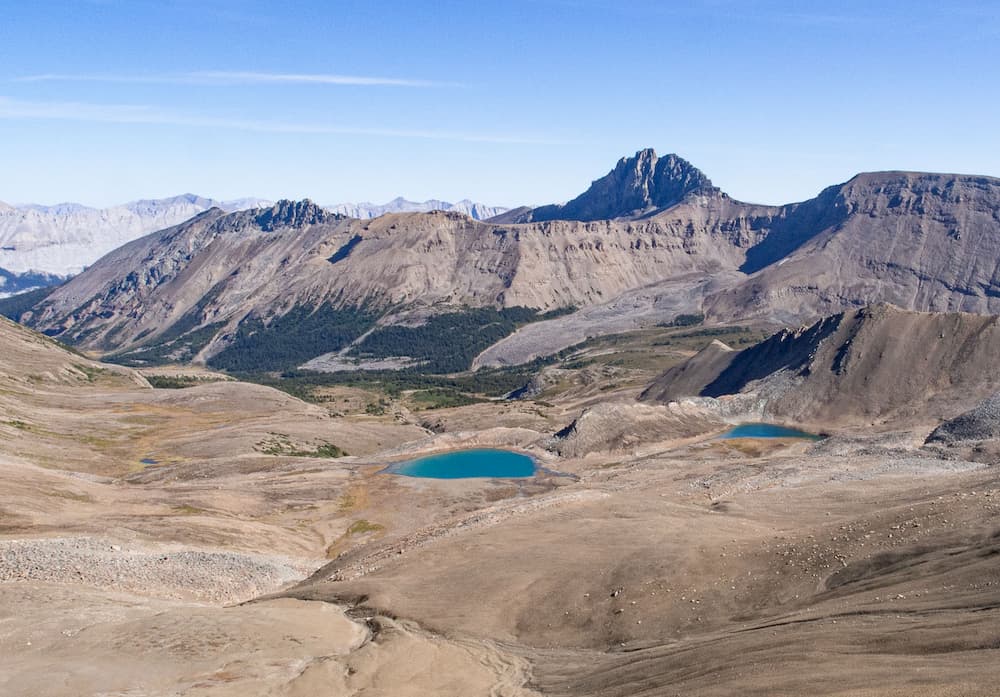
The Skyline Trail starts at the beautiful Maligne Lake and follows a ridge line for most of its length. With most of the hike above treeline, the trail rewards you with 360-degree views of Jasper National Park.
It’s a point-to-point hike, so you’ll need to find a way to get back to your car (hitch-hike or bring two cars).
Permit availability
Updated every 10 min
Click for details
Click for details
Click for details
Click for details
Click for details
Click for details
Click for details
Click for details
Click for details
Click for details
Click for details
Click for details
Click for details
Click for details
Click for details
Click for details
Click for details
Click for details
Click for details
Click for details
Click for details
Click to get notified when we find any
Click to get notified when we find any
Click to get notified when we find any
Click to get notified when we find any
Click to get notified when we find any
Click to get notified when we find any
Click to get notified when we find any
Click to get notified when we find any
Click to get notified when we find any
Click to get notified when we find any
Click to get notified when we find any
Click to get notified when we find any
Click to get notified when we find any
Berg Lake Trail
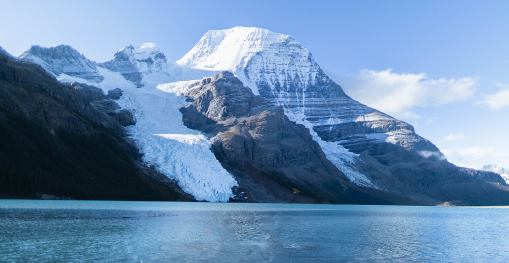
And last but not least, Berg Lake. It doesn’t get more epic than camping in front of the magestic Berg Glacier tumbling down from Mount Robson.
Unfortunately, you’ll have to wait to visit. The trail is closed for maintenance and won’t reopen until 2025.
Permit availability
Updated every 10 min
Click for details
Click for details
Click for details
Click for details
Click for details
Click for details
Click for details
Click for details
Click for details
Click for details
Click for details
Click for details
Click for details
Click for details
Click for details
Click for details
Click for details
Click for details
Click for details
Click for details
Click for details
Click to get notified when we find any
Click to get notified when we find any
Click to get notified when we find any
Click to get notified when we find any
Click to get notified when we find any
Click to get notified when we find any
Click to get notified when we find any
Click to get notified when we find any
Click to get notified when we find any
Click to get notified when we find any
Click to get notified when we find any
Click to get notified when we find any
Click to get notified when we find any
And that’s a wrap! Canada has a lot more to offer. Check out the full list of backpacking trips.
Never miss a permit deadline ever again!
Once a month, receive the list of top permits that are opening up