All the backpacking trips with a Half Dome summit
Summiting Half Dome in a day is a unique experience. But it’s a challenging hike, and permits are hard to get. At 15 miles and 5,000 feet of elevation gain, most people take over 10 hours to complete it. Even as a fast hiker, you will run into a traffic jam at the Half Dome cables. To top it off, that’s only if you can score a permit. Day-hiking permits are issued via a lottery where the chance of winning was only 18% in 2024 .
There is a better way. Backpacking! Having summited Half Dome three times, I can say that backpacking is the best way to go. You can take your time, avoid crowds, and backpacking permits are easier to get. And unlike day-hiking permits, 40% of backpacking permits are issued on a first-come, first-serve basis. No need to pay to enter a lottery that may prove unsuccessful.
Itineraries
In Yosemite, seven backpacking trailheads are eligible for a Half Dome summit (you can request access when picking up your backpacking permit). Below are the shortest backpacking trips from each trailhead.
Which one is best? They all offer something unique. Trips starting from Happy Isles are the most convenient and shortest, but also the most strenuous. Trips starting from Glacier Point Road are scenic and have the least elevation change. And trips starting from Tioga Road are longer, mostly downhill, and more secluded.
From
Happy Isles
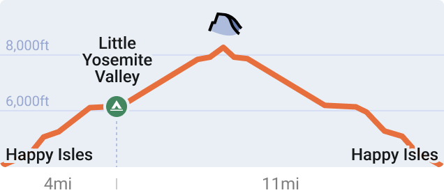
This is the most convenient and direct route.
Day 1
Follow the Mist Trail and camp at Little Yosemite Valley Camp on your first night.
Day 2
Leave camp early with a day pack and summit Half Dome. Bring plenty of water since there is no water past Little Yosemite Valley Camp. On the way down, stop by Little Yosemite Valley Camp to pack camp.
From the top of Nevada Falls, I recommend taking the John Muir Trail instead of the Mist Trail to avoid the steep stairs and crowds.
Recreation.gov entry point
From
Happy Isles Past LYV
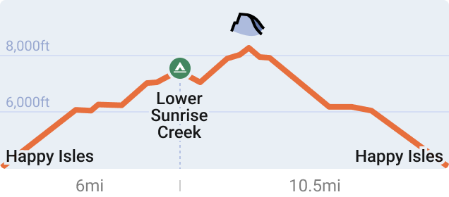
This option also starts from Happy Isles, but this permit prevents you from camping at Little Yosemite Valley Camp.
Day 1
I recommend camping along Sunrise Creek. It’s 2 miles past Little Yosemite Valley Camp, or one mile past the junction between the John Muir Trail and the Half Dome Trail.
Day 2
Drop off your backpack at the junction between the John Muir Trail and the Half Dome Trail and summit Half Dome with a day pack. Bring plenty of water since there is no water between Sunrise Creek and Little Yosemite Valley Camp. On the way down, pick up your backpack and continue to Happy Isles.
From the top of Nevada Falls, I recommend taking the John Muir Trail instead of the Mist Trail to avoid the steep stairs and crowds.
Recreation.gov entry point
From
Glacier Point
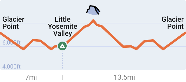
This route has less elevation gain than trips starting from Happy Isles.
Day 1
From Glacier Point, take the scenic Panorama Trail and camp at Lower Yosemite Valley Camp.
Day 2
Leave camp early with a day pack and summit Half Dome. Bring plenty of water since there is no water past Lower Yosemite Valley Camp. On the way down, stop by Lower Yosemite Valley Camp to pack camp before continuing to Glacier Point.
Recreation.gov entry point
From
Mono Meadow
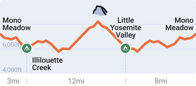
Day 1
Camp 3 miles from the start, by Illilouette Creek. You have to stop there. It’s required when starting from Mono Meadow.
Day 2
Hike to Little Yosemite Valley Camp and set up camp. Summit Half Dome with a day pack. Bring plenty of water since there is no water past Little Yosemite Valley Camp.
Day 3
Head back to Mono Meadow.
Recreation.gov entry point
From
Sunrise
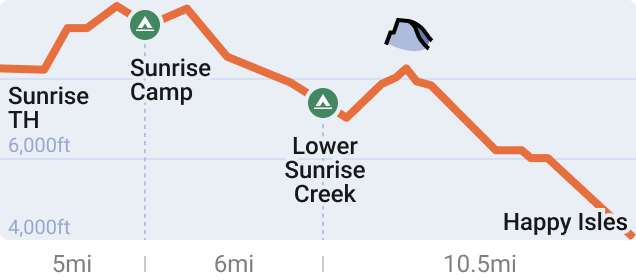
Mostly downhills. This is a one-way route, so use two cars or take YARTS to get back to Tuolumne Meadows.
Day 1
Camp at Sunrise High Sierra Camp.
Day 2
Camp at Lower Sunrise Creek. Lower Sunrise Creek isn’t a marked campsite — you will have to find a spot along the river.
Day 3
Drop off your backpack at the junction with the Half Dome Trail and summit Half Dome with a day pack. Bring plenty of water since there is no water between Sunrise Creek and Little Yosemite Valley Camp. Hike down to Happy Isles.
Recreation.gov entry point
Recreation.gov exit point
From
Cathedral Lakes
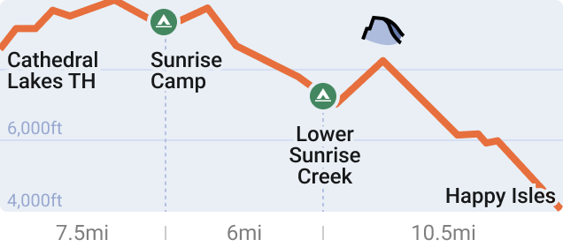
It’s the popular “Tuolumne Meadows to Yosemite Valley” route. This is a one-way route, so use two cars or take YARTS to get back to Tuolumne Meadows.
Day 1
Camp at Sunrise High Sierra Camp.
Day 2
Camp at Lower Sunrise Creek. Lower Sunrise Creek isn’t a marked campsite — you will have to find a spot along the river.
Day 3
Drop off your backpack at the junction with the Half Dome Trail and summit Half Dome with a day pack. Bring plenty of water since there is no water between Sunrise Creek and Little Yosemite Valley Camp. Hike down to Happy Isles.
Recreation.gov entry point
Recreation.gov exit point
From
Rafferty Creek
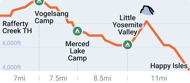
It’s the longest and most secluded route. This is a one-way route, so use two cars or take YARTS to get back to Tuolumne Meadows.
Day 1
Camp at Vogelsang High Sierra Camp.
Day 2
Camp at Merced Lake High Sierra Camp.
Day 3
Camp at Little Yosemite Valley Camp.
Day 4
Leave camp early with a day pack and summit Half Dome. Bring plenty of water since there is no water past camp. On the way down, stop by Little Yosemite Valley Camp to pack camp before heading to Happy Isles.
Recreation.gov entry point
Recreation.gov exit point
Permit availability
Here is the current number of available permits per start date. Additional permits are released 7 days in advance at 7 AM PT .
No permits left? It’s not too late. Create an alert to get notified when we find permits.
Happy Isles
Happy Isles Past LYV
Glacier Point
Mono Meadow
Sunrise
Cathedral Lakes
Rafferty Creek
Never miss a permit deadline ever again!
Once a month, receive the list of top permits that are opening up