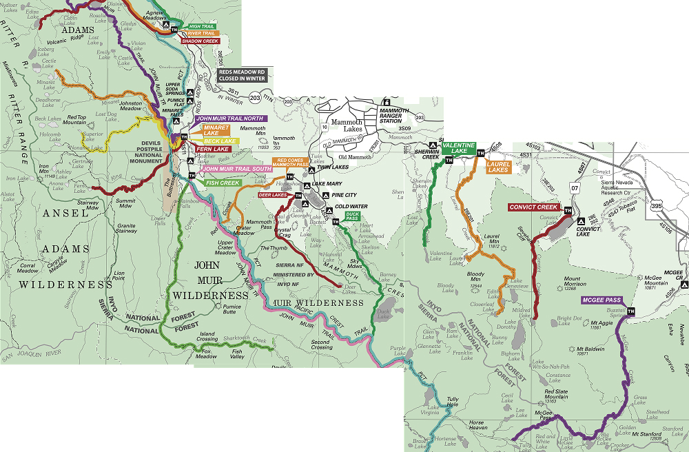
Inyo National Forest Map
Want to backpack in Inyo National Forest, but not sure which permit to get? You’re not alone. Here is the map of Inyo National Forest’s trailheads.
Hoover & Hall
Lundy Canyon (Non Quota)
Lakes Canyon (Non Quota)
Saddlebag Lake (Non Quota)
Warren Fork (Non Quota)
Lee Vining
Glacier Canyon
Gibbs Lake
Bloody Canyon
June Lakes
Parker Lake
Rush Creek
Yost / Fern Lakes
Agnew Meadows
High Trail
River Trail
Shadow Creek
Devils Postpile
John Muir Trail North of Devils Postpile
Minaret Lake
Beck Lake
Fern Lake
John Muir Trail South of Devils Postpile
Fish Creek
Mammoth Lakes Basin
Red Cones
Deer Lakes
Duck Pass
Sherwin Lakes
Valentine Lake
Laurel Lakes
Convict Creek
McGee Pass
Rock Creek
Hilton Lakes
Mono Pass
Tamarack Lakes
Little Lakes Valley
Pine Creek
Italy Pass
Pine Creek
Gable Lakes
Horton Lakes
Upper Buttermilk
Sabrina & North Lake
Piute Pass
Lamarck Lakes
Sabrina Lake
George Lake
South Lake
Tyee Lakes
Treasure Lakes
Bishop Pass -South Lake
Baker and Green Lakes
Big Pine
Big Pine Creek South Fork
Big Pine Creek North Fork
Big Pine Creek North Fork (Pack Outfit)
Big Pine Creek North Fork (Outfitter)
Birch Lake
Red Lake
Independence
Taboose Pass
Sawmill Pass
Baxter Pass
Onion Valley
Golden Trout Lakes
Kearsarge Pass
Shepherd Pass
George Creek
Mt. Whitney
North Fork of Lone Pine Creek
Mt. Whitney (Trail Crest Exit)
Meysan Lake
Tuttle Creek
Horseshoe Meadows
Cottonwood Lakes
Cottonwood Pass
Trail Pass (Non Quota)
South Sierra
Blackrock (Non Quota)
Olancha Pass (Non Quota)
Haiwee Pass (Non Quota)
Kennedy Meadows (Non Quota)
Never miss a permit deadline ever again!
Once a month, receive the list of top permits that are opening up