The John Muir Trail Interactive Guide
The mobile version is missing some features. View this page on desktop to access everything!
Planning your John Muir Trail adventure can be quite challenging due to its remote and lengthy nature. Spanning 210 miles without encountering any towns, resupplying for food can pose a significant challenge. Additionally, securing permits can be a daunting task, as the JMT ranks among the country’s most popular trails. Nevertheless, with meticulous planning, the John Muir Trail offers a once-in-a-lifetime experience.
I’m Jordan, and this interactive guide is the resource I wish I had before embarking on my JMT journeys in 2010 and 2015. While I provide recommendations for planning your ideal trip, it’s important to note that each situation is unique. This guide empowers you to personalize every aspect of your journey, from choosing trailheads and campsites to arranging resupplies and transportation options.
When to go

Most JMT hikers typically begin their journey in July or August. Starting the trail too early in the season, when the mountain passes are still blanketed in snow, can be hazardous and impractical. However, it’s crucial to keep in mind that conditions vary from year to year. Some years may see snow-free passes as early as June, while in other years, snow can persist until September. Until most snow has melted you can expect streams to be at their highest level, making stream crossing hazardous.
During the early season when the snow is melting, mosquitoes can pose a nuisance. If you plan to hike in July or early August, I recommend packing long-sleeved shirts and pants to help protect against these pesky insects.
On the flip side, hiking later in the season comes with the risk of wildfires. Unfortunately, wildfires have been increasingly problematic in recent years, so it’s essential to stay informed and prepared for potential fire-related challenges during your journey.
Recommendation
Because permits are issued six months in advance (see below), it’s too early to know what the conditions will be in the summer. Therefore, I recommend checking the conditions a few months before your trip and adjusting your itinerary accordingly.
Plans change, so many people will cancel their permit. If you don’t mind planning at the last minute, you can try to snag a canceled permit. We can text you when we find permits.
Current conditions
- Current and historical snow levels
- Real-time satellite imagery
- Facebook group and Subreddit for first-hand reports
Permits and trailheads
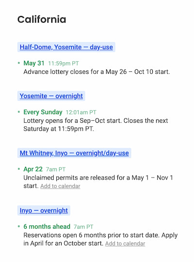
The first step in planning for the John Muir Trail is getting a hiking permit. Because the chances of winning a permit are low, I recommend waiting to get a permit before planning the rest of your trip.
A permit allows you to start your trip on a given date at a given trailhead and is valid throughout your trip. There are four major trailheads:
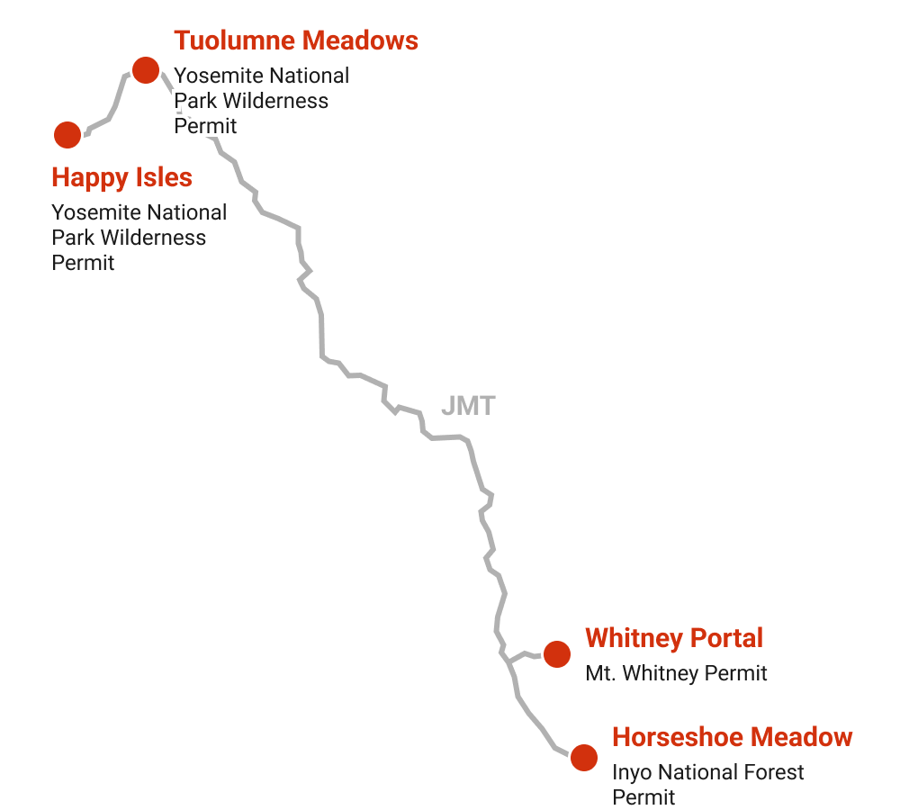
Each trailhead has a different reservation process. The Happy Isles (traveling southbound) and Whitney Portal (traveling northbound) trailheads are the two “official” trailheads. Tuolumne Meadows or Horseshoe Meadows are popular alternatives with better odds of snagging a permit.
Here is how to apply for each permit:
Happy Isles
Official southbound trailhead
Permit
Yosemite National Park Wilderness Permit
Entry point (as shown on Recreation.gov)
Happy Isles → Past LYV (Donohue Pass Eligible)
Reservations
Tuolumne Meadows
22 mi shorter and skips Half Dome
Permit
Yosemite National Park Wilderness Permit
Entry point (as shown on Recreation.gov)
Lyell Canyon (Donohue Pass Eligible)
Reservations
Whitney Portal
Official northbound trailhead
Permit
Mt. Whitney Permit
Entry point (as shown on Recreation.gov)
Mt. Whitney Trail (Overnight)
Reservations
Horseshoe Meadows
5 mi longer and skips Mt. Whitney
Permit
Inyo National Forest Wilderness Permit
Entry point (as shown on Recreation.gov)
Cottonwood Pass or Cottonwood Lakes
Reservations
Resupplies
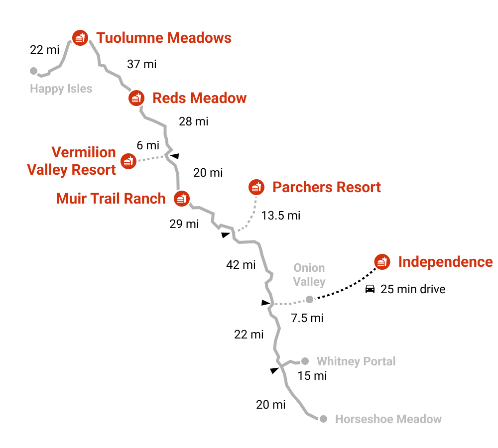
If you don’t want to carry too much food, you’ll probably need to resupply along the way. Most people pack at most one week’s worth of food. Even if you can carry more, it probably won’t fit in your (required) bear canister. Here are your resupply options:
Tips:
- Vermilion Valley Resort is a favorite resupply stop, but it requires an extra 12-mile hike or a ferry ride.
- For a 3-week trip, you’ll most likely need to resupply in Independence, which requires a 15-mile hike and a shuttle ride.
Red’s Meadow Resort
Right off the trail
Amenities
Store (camp food, fuel), restaurant, campground, showers, resupply service
Vermilion Valley Resort
12 mi round-trip or ferry ride
Amenities
Store (camp food, fuel), restaurant, campground, showers, cabins, resupply service
Parchers Resort
27 mi / 6,000ft+ round-trip
Amenities
Store (camp food, fuel), restaurant, showers, cabins, resupply service
Independence
15 mi / 5,200ft+ round-trip + shuttle ride
Amenities
Hotels, restaurants, post office, resupply service
Check out the Mt Williamson Motel for hiker services
Itineraries
Hikers usually take 19 days to complete the JMT, with an additional rest day (a.k.a. “zero-day”). The longer your trip, the more resupply stops you’ll have to make. Therefore, some hikers opt for a shorter trip (~15 days) to minimize resupply stops to a single one (in Muir Trail Ranch or Vermilion Valley Resort).
Popular itineraries
| From Happy Isles | 15 days 22 days |
|---|---|
| From Tuolumne Meadows | 14 days 20 days |
| From Horseshoe Meadow | 16 days 23 days |
| From Whitney Portal | 15 days 22 days |
Side-trips
There are two popular side trips, Half Dome and Mt. Whitney. While Mt. Whitney is the terminus of the JMT, it adds a 4-mile detour when starting or ending at Whitney Portal, or a 16-mile detour when starting from Horseshoe Meadow.
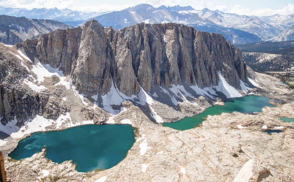
The Happy Isles trailhead offers the chance to summit the coveted Half Dome, adding 4 miles to your trip.
Half Dome
4 mi / 1,800ft+ round-trip
Only available from the Happy Isles trailhead
Mt. Whitney Summit
4 mi / 1,100ft+ round-trip
Elevation chart
Want to customize your itinerary? Use the elevation chart below to pick campsites. But do not overthink it. Almost everybody’s plans change once on the trail.
I’ve only listed the most popular campsites, but you should be able to find places to camp almost anywhere. Make sure to camp at least 100 feet from the trail or water, avoiding vegetation and explicitly prohibited areas.
I recommend camping below 10,000 feet for two reasons. First, nights get a lot colder above 10,000 feet. Second, campfires are only permitted below 10,000 feet (however, no campfires are allowed when the risk of wildfire is high).
Transportation
The John Muir Trail is a one-way hike, so you’ll need to find a way to get on and off the trail.
By car
One option is to drive two cars and leave one at each trailhead. Long-term parking is allowed at all trailheads at the following locations:
| Trailhead | Parking |
|---|---|
| Happy Isles | Park at the Curry Village parking lot and hike 1 mile to or take the free shuttle to the trailhead. |
| Tuolumne Meadows | Park at the Tuolumne Meadows Wilderness Center, where you can also grab your permit. |
| Whitney Portal | Park at the Whitney Portal parking lot. |
| Horseshoe Meadows | Park at the Cottonwood Pass or Cottonwood Lakes trailheads. |
Public Transportation
The other popular option is to take public transportation. Two services, YARTS and ESTA, can get you to most places along the Sierra Nevada.
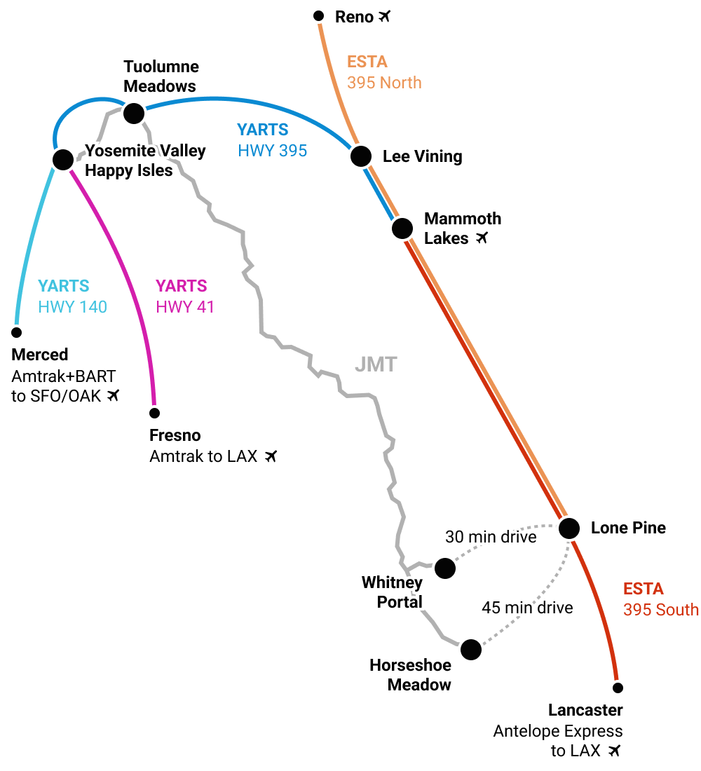
Unfortunately, there is a missing link between Whitney Portal / Horseshow Meadow and Lone Pine. You can hitchhike or schedule a ride with the Lone Pine Chamber of Commerce.
Additional resources
- Guidebook: John Muir Trail: The Essential Guide to Hiking America’s Most Famous Trail by Elizabeth Wenk
- On-trail app: FarOut
- Facebook Group
- Subreddit
And that’s a wrap! Questions or comments? Shoot me an email; I’d love to hear from you!
Never miss a permit deadline ever again!
Once a month, receive the list of top permits that are opening up